
Introduction
Navigation is one of the most important parts of flying a jet aircraft. Pilots need to know where the aircraft is, where it is heading, which route it is following, and how far it is from important points along that route. Modern jet aircraft use several navigation systems and sources to provide this information.
For a new learner, aircraft navigation can initially seem complicated because it involves terms such as VOR, DME, GNSS, GPS, INS, IRS, ILS, FMS, heading, track, bearing, and waypoints. However, these concepts become easier to understand when they are studied step by step.
Modern jets generally do not depend on one navigation system alone. Different sources can provide position, direction, distance, or guidance information, while integrated systems can combine this information to support the flight crew.
This guide explains the basic navigation concepts and major navigation systems used in jet aircraft in a simple way for beginners.
What Is a Jet Navigation System?
A jet navigation system is the collection of equipment and technologies used to help determine and manage an aircraft’s position, direction, route, and movement during flight.
It can provide information about:
- Aircraft position
- Direction of travel
- Distance from navigation references
- Planned route
- Waypoints
- Heading
- Track
- Course
- Approach guidance
The term “jet navigation system” does not necessarily refer to one physical device. A modern aircraft can use several navigation sources together.
For example, a jet may receive information from satellite navigation, inertial reference systems, and ground-based navigation aids. The aircraft’s flight management system can then use available navigation information as part of its overall flight management functions.
The exact navigation architecture depends on the aircraft type, equipment configuration, and operating environment.
Why Navigation Is Important in Jet Aircraft
A jet aircraft can travel hundreds or thousands of kilometers during a flight. Pilots therefore need accurate and continuously monitored navigation information.
Navigation is important during every major phase of flight.
Departure
After leaving the runway, the aircraft follows a planned departure route. Navigation information helps the crew monitor the aircraft’s position and route.
Climb
During the climb, the aircraft transitions from the airport environment into the en-route portion of the flight.
En-Route Flight
During cruise, navigation systems help pilots remain on the planned route and monitor their position relative to waypoints and other navigation references.
Descent
As the aircraft approaches its destination, navigation information becomes increasingly important for following the published arrival route.
Approach
Approach procedures may require precise lateral and vertical guidance. Systems such as ILS can provide this guidance for suitable approaches.
Landing
During the final stages of flight, pilots use the appropriate navigation and approach guidance systems along with visual references and aircraft instruments.
Basic Navigation Concepts New Learners Should Understand
Before studying individual navigation systems, it is important to understand some basic aviation terms.
Heading
Heading describes the direction in which the aircraft’s nose is pointing.
For example, if an aircraft’s heading is 090°, its nose is pointing approximately east.
Heading does not necessarily mean that the aircraft is moving directly east over the ground because wind can affect the aircraft’s actual path.
Track
Track is the actual direction in which the aircraft is moving over the ground.
Wind can cause the aircraft’s track to differ from its heading.
This distinction is important for understanding aircraft navigation.
Course
Course generally refers to a desired direction of travel or planned path.
A pilot may need to establish or maintain a particular course to follow a route.
Bearing
Bearing describes the direction of a reference point relative to the aircraft or, depending on the navigation context, the direction from one point to another.
Understanding bearing becomes particularly useful when learning traditional radio-navigation systems.
Distance
Distance indicates how far the aircraft is from a particular point or navigation reference.
Different systems can provide distance information in different ways.
Position
Position identifies where the aircraft is geographically located.
Modern aircraft can determine position using sources such as satellite navigation and inertial systems.
Waypoint
A waypoint is a defined geographical point used in flight planning and navigation.
Modern routes can contain many waypoints, creating a structured path between departure and destination.
Route
A route is the planned sequence of navigation points and procedures that an aircraft follows during a flight.
It can include departure procedures, airways, waypoints, arrival procedures, and an approach.
Main Types of Navigation Systems Used in Jet Aircraft
Jet aircraft can use several different navigation systems and sources.
Some important examples include:
- VOR
- DME
- ADF/NDB
- ILS
- GNSS/GPS
- INS
- IRS
- FMS
Each has a different purpose.
Some systems provide navigation references, some provide position information, some provide approach guidance, and some integrate information from several sources.
VOR Navigation Explained
VHF Omnidirectional Range, commonly called VOR, is a ground-based radio navigation system.
A VOR station transmits signals that allow an aircraft’s navigation equipment to determine its direction relative to the station.
One of the most important concepts associated with VOR is the radial.
What Is a VOR Radial?
A radial is a magnetic direction extending outward from a VOR station.
For example, the 090° radial extends eastward from the station.
A pilot can use VOR information to determine the aircraft’s position relative to the station and establish a desired course.
How Pilots Use VOR
VOR can support:
- En-route navigation
- Terminal-area navigation
- Position awareness
- Cross-checking
For beginners, the key idea is simple:
VOR provides directional information relative to a ground station.
The exact operational use depends on aircraft equipment, navigation procedures, and the applicable aviation environment.
DME Explained
Distance Measuring Equipment, or DME, provides distance information between an aircraft and a compatible ground station.
The distance displayed by DME is generally slant-range distance, meaning it represents the direct distance between the aircraft and the ground station rather than simply the horizontal distance across the ground.
DME can be used alongside VOR.
For example, a pilot may have:
- Directional information from VOR
- Distance information from DME
Together, these can provide useful information about the aircraft’s position relative to a navigation station.
DME is therefore more than simply a way to estimate how far an aircraft has travelled.
ADF and NDB Navigation
Automatic Direction Finder (ADF) is an aircraft navigation instrument associated with Non-Directional Beacons (NDBs).
An NDB is a ground-based radio beacon. The ADF can indicate the relative direction of the beacon from the aircraft.
This allows pilots to determine where the navigation reference is located relative to the aircraft.
ADF/NDB navigation is an important part of aviation navigation history and remains relevant in some operational environments, although many modern aircraft increasingly rely on newer navigation technologies.
Understanding ADF and NDB can still help student pilots develop a broader understanding of how aircraft navigation evolved.
ILS and Navigation During Approach
The Instrument Landing System (ILS) provides precise approach guidance for suitably equipped aircraft and runways.
It primarily provides:
- Lateral guidance
- Vertical guidance
Localizer
The localizer provides lateral guidance.
It helps the pilot or aircraft guidance system determine whether the aircraft is to the left or right of the desired approach path.
Glideslope
The glideslope provides vertical guidance.
It helps establish whether the aircraft is above or below the desired vertical approach path.
ILS Receiver
The aircraft’s ILS equipment receives the relevant signals and provides guidance information to the flight crew or aircraft systems.
ILS is mainly associated with instrument approaches rather than serving as the aircraft’s complete navigation system for an entire flight.
GNSS and GPS Navigation
Satellite navigation has become an important part of modern aviation.
What Is GPS?
GPS, or Global Positioning System, is a satellite navigation system operated by the United States.
It allows properly equipped systems to determine geographical position using signals from satellites.
What Is GNSS?
GNSS stands for Global Navigation Satellite System.
It is a broader term that can include multiple satellite navigation constellations.
Therefore:
GPS is one satellite navigation system, while GNSS is the broader category.
Satellite navigation can support:
- Position determination
- Route navigation
- Waypoint navigation
- Area navigation
- Flight management
Modern aircraft may combine satellite-derived information with other navigation sources rather than relying on satellite navigation alone.
Inertial Navigation System Explained
An Inertial Navigation System (INS) determines aircraft movement using onboard sensors.
The basic concept involves measuring movement through components such as:
- Gyroscopes
- Accelerometers
- Initial position information
The system can calculate changes in aircraft position as the aircraft moves.
One advantage of inertial navigation is that it does not need to continuously depend on external radio navigation signals to calculate movement.
What Is Inertial Drift?
Inertial systems are not perfectly accurate indefinitely.
Small measurement errors can accumulate over time, resulting in inertial drift.
Because of this, modern aircraft can use other navigation sources to update or cross-check inertial information.
For beginners, the key concept is:
An inertial system can calculate aircraft movement independently, but small errors can accumulate over time.
Inertial Reference System
An Inertial Reference System (IRS) is an important source of aircraft motion and reference information.
Depending on the aircraft architecture, an IRS can provide information related to:
- Attitude
- Heading
- Aircraft movement
- Navigation-related information
The exact terminology and system architecture can vary between aircraft.
Modern aircraft commonly integrate inertial reference information with other navigation systems.
What Is a Flight Management System?
The Flight Management System (FMS) is an integrated aircraft system that helps manage various aspects of flight planning and navigation.
It can support functions related to:
- Flight planning
- Route management
- Navigation
- Performance calculations
- Guidance inputs
An FMS may receive information from several navigation sources.
This creates an important distinction:
GPS is a navigation source, while the FMS is an integrated flight-management system that can use information from multiple sources.
An FMS should therefore not simply be described as “the aircraft’s GPS.”
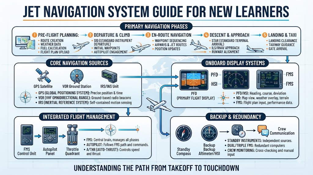
How Jet Navigation Systems Work Together
Modern jet aircraft often combine information from multiple navigation sources.
A simplified example could involve:
GNSS + IRS + DME/VOR → Navigation System → FMS → Navigation Display
This is only a simplified representation. Actual aircraft architectures are much more sophisticated and vary between aircraft.
The important concept for beginners is that navigation information can come from several sources.
This provides additional information for monitoring and can support redundancy.
Navigation Displays in Jet Aircraft
Pilots need a practical way to see navigation information.
Modern aircraft can use several displays.
Primary Flight Display
The Primary Flight Display (PFD) primarily provides important flight information such as attitude, airspeed, altitude, and heading.
Depending on the aircraft, additional navigation-related information may also be presented.
Navigation Display
The Navigation Display (ND) can present information related to the aircraft’s route and navigation environment.
It may show items such as:
- Planned route
- Waypoints
- Heading
- Track
- Navigation references
- Weather information on suitably equipped aircraft
Flight Management Computer Interface
Pilots can enter and manage flight-plan information through the aircraft’s flight management interface.
The exact interface varies significantly between aircraft.
Understanding Waypoints and Airways
Modern flight routes are often constructed from a sequence of geographical points.
Waypoints
A waypoint identifies a specific geographical location used for navigation.
Airways
An airway is a defined route structure that can connect navigation points.
Departure Procedures
Standard Instrument Departures, where applicable, provide structured procedures for leaving an airport.
Arrival Procedures
Standard arrival procedures can guide aircraft toward the destination area.
Approach Procedures
Approach procedures provide the published route and guidance needed to transition toward the runway.
Together, these elements can create a structured route from departure to destination.
How Pilots Plan a Jet Flight Route
A simplified flight route may look like:
Departure Airport → Departure Procedure → En-Route Waypoints → Arrival Procedure → Approach → Runway
The actual process is considerably more detailed.
Flight planning can involve:
- Aircraft performance
- Weather
- Airspace restrictions
- Navigation requirements
- Fuel planning
- Published procedures
- Air traffic control requirements
- Operational regulations
The route displayed in the aircraft is therefore part of a much larger operational planning process.
Navigation During Different Phases of Flight
Navigation During Departure
During departure, pilots transition from airport-based operations to the planned departure route.
Navigation information helps the crew monitor the aircraft’s position relative to the published procedure.
Navigation During Climb
During climb, the aircraft follows the planned route while the crew monitors position, heading, altitude, and other flight parameters.
Navigation During Cruise
Cruise navigation usually involves following a sequence of waypoints or route segments.
Modern systems can provide continuous navigation information while pilots monitor the route and aircraft position.
Navigation During Descent
During descent, the aircraft transitions toward the destination using published arrival procedures where applicable.
Navigation accuracy becomes increasingly important as the aircraft moves into more structured terminal airspace.
Navigation During Approach
Approach procedures can require precise navigation.
Depending on the procedure, aircraft may use systems such as GNSS, ILS, or other approved navigation guidance.
Navigation During Landing
During landing, the aircraft follows the applicable approach and landing guidance while pilots maintain awareness of the runway environment and aircraft position.
Jet Navigation System Comparison
| Navigation System | Main Function | Typical Information Provided | Common Use |
|---|---|---|---|
| VOR | Ground-based radio navigation | Direction/radial | En-route and terminal navigation |
| DME | Distance measurement | Slant-range distance | Position and navigation support |
| ADF/NDB | Direction finding | Relative bearing | Traditional navigation |
| ILS | Precision approach guidance | Lateral and vertical guidance | Instrument approaches |
| GNSS | Satellite navigation | Position and navigation data | Modern navigation |
| INS/IRS | Inertial reference/navigation | Motion, attitude, heading and navigation information | Integrated aircraft navigation |
| FMS | Integrated flight management | Route, navigation and performance-related information | Flight management |
The availability and exact function of each system depend on the aircraft and its equipment configuration.
Traditional vs Modern Jet Navigation
Aircraft navigation has developed significantly over time.
Traditional navigation relied heavily on ground-based systems such as VOR, DME, and NDB.
Later, inertial navigation allowed aircraft to calculate movement using onboard sensors.
Satellite navigation then provided highly useful position information over large geographical areas.
Modern aircraft can integrate several of these technologies.
| Traditional Approach | Modern Approach |
|---|---|
| Greater dependence on ground-based navigation aids | Greater use of integrated navigation sources |
| VOR and NDB commonly important | GNSS commonly integrated |
| Separate navigation instruments | Integrated digital displays |
| More manual navigation calculations | Greater automation and route management |
| Limited navigation-source integration | Multiple navigation sources can be integrated |
Modern navigation has not simply replaced every traditional system. Different aircraft and operating environments continue to use different combinations of technologies.
Navigation Accuracy and Reliability
Navigation systems have limitations.
Accuracy and reliability can be affected by:
- Sensor errors
- Signal availability
- Satellite signal conditions
- Inertial drift
- Equipment condition
- Navigation database information
- System configuration
- Environmental or operational factors
This is why pilots monitor navigation information rather than assuming that one source is always correct.
Cross-checking is an important part of professional flight operations.
Navigation Databases
Modern aircraft navigation systems can use databases containing information such as:
- Airports
- Runways
- Waypoints
- Airways
- Navigation facilities
- Instrument procedures
These databases are important because flight-management systems need accurate route and procedure information.
Navigation databases are maintained and updated according to approved operational processes.
Pilots and operators must also ensure that the appropriate database version is being used for the operation.
Navigation System Redundancy
Aircraft are designed with reliability and redundancy in mind.
Depending on the aircraft, multiple navigation sources may be available.
For example, an aircraft might have access to:
- Multiple inertial reference sources
- Satellite navigation
- Radio navigation
- Distance information
- Approach guidance
Having multiple sources can help provide additional information for monitoring and support continued navigation when one source becomes unavailable, subject to the aircraft’s approved procedures and capabilities.
Common Navigation Terms Beginners Should Know
VOR
A ground-based radio navigation system that provides directional information relative to a station.
DME
A system that provides slant-range distance from a compatible ground station.
NDB
A ground-based non-directional radio beacon.
ADF
Aircraft equipment that provides relative direction to an NDB or compatible signal.
GNSS
The broader category of satellite navigation systems.
GPS
A satellite navigation system operated by the United States.
INS
An inertial navigation system that calculates movement using onboard sensors.
IRS
An inertial reference system that provides important aircraft reference and motion information.
FMS
An integrated system used for flight planning, navigation, performance-related functions, and other flight-management tasks.
Waypoint
A defined geographical point used in flight planning and navigation.
Radial
A magnetic direction extending outward from a VOR station.
Bearing
The direction of one location relative to another reference.
Course
A desired direction or planned path.
Track
The actual direction of aircraft movement over the ground.
Heading
The direction in which the aircraft’s nose is pointing.
ILS
An instrument approach system providing lateral and vertical guidance.
Localizer
The ILS component providing lateral guidance.
Glideslope
The ILS component providing vertical guidance.
Navigation Database
A database containing route, waypoint, airport, navigation facility, and procedure information used by compatible aircraft systems.
Common Beginner Mistakes When Learning Jet Navigation
Confusing Heading With Track
A common mistake is assuming that the aircraft’s heading and track must always be identical.
Wind can cause the aircraft’s ground track to differ from its heading.
Thinking GPS Is the Entire Navigation System
GPS provides satellite-based position information, but modern aircraft can use multiple navigation sources.
Confusing FMS With GPS
The FMS is an integrated flight-management system. GPS is a satellite navigation source that may provide information to the aircraft’s navigation systems.
Assuming DME Gives Simple Ground Distance
DME normally provides slant-range distance. This is different from simply measuring horizontal distance across the ground.
Believing Navigation Systems Never Make Errors
All navigation technologies have limitations.
Pilots need to understand those limitations and monitor available information.
Assuming Every Jet Uses Identical Equipment
Different aircraft types can have different navigation architectures, displays, databases, and system configurations.
Memorizing Terms Without Understanding Their Purpose
Simply remembering abbreviations is not enough.
A learner should understand what each system does and how it contributes to the overall navigation process.
What New Learners Should Study First
A logical learning sequence can make aircraft navigation easier to understand.
Start with:
- Basic aircraft directions
- Heading and track
- Bearing and course
- Waypoints
- VOR
- DME
- ADF/NDB
- ILS
- GNSS/GPS
- INS/IRS
- FMS
- Navigation displays
- Integrated navigation concepts
Learning these subjects in this order helps build a foundation before moving into more complex systems.
Navigation Systems and Pilot Situational Awareness
Navigation equipment provides valuable information, but pilots still need to understand what the information means.
Good navigation awareness involves knowing:
- Where the aircraft is
- Where it is going
- Which route it is following
- What waypoint comes next
- Which navigation source is being used
- Whether different sources agree
- What limitations may apply
This is why learning navigation principles remains important even in highly automated aircraft.
Automation can reduce workload, but pilots still need the knowledge required to monitor the system and recognize when something does not appear correct.
Practical Example: Understanding a Simple Jet Route
Consider a simplified hypothetical route:
Departure → Waypoint A → Waypoint B → Arrival → Approach → Runway
After departure, the aircraft may use its navigation systems to determine its position and follow the planned route toward Waypoint A.
It then continues toward Waypoint B before transitioning to the published arrival procedure.
Near the destination, the aircraft follows the applicable arrival and approach procedure.
For an ILS approach, the localizer can provide lateral guidance while the glideslope provides vertical guidance.
This example is intentionally simplified. Actual flight procedures depend on the aircraft, airport, airspace, navigation equipment, weather, regulations, and published procedures.
How Navigation Systems Support Flight Safety
Reliable navigation contributes to several important aspects of flight operations.
Route Accuracy
Navigation systems help aircraft remain on the intended route.
Situational Awareness
Pilots can monitor the aircraft’s position relative to waypoints, routes, and other references.
Procedure Compliance
Navigation information supports the execution of published departure, arrival, and approach procedures.
Approach Guidance
Systems such as ILS can provide precise guidance during suitable instrument approaches.
Position Monitoring
Multiple navigation sources can help crews cross-check aircraft position.
Coordination With Air Traffic Control
Accurate navigation supports the aircraft’s ability to follow assigned routes and procedures.
However, navigation systems alone do not guarantee flight safety. Safe operations depend on properly functioning equipment, trained pilots, accurate information, approved procedures, appropriate monitoring, and effective decision-making.
Frequently Asked Questions
1. What is a jet navigation system?
A jet navigation system is the collection of aircraft equipment and navigation sources used to determine position, direction, distance, route, and other navigation information during flight.
2. Is GPS the same as a jet navigation system?
No. GPS is one satellite navigation system. A modern jet can use GPS or other GNSS information together with inertial and ground-based navigation sources.
3. What is the difference between FMS and GPS?
GPS provides satellite-based positioning information. An FMS is an integrated system that can manage flight-plan information, navigation, performance-related functions, and guidance inputs using information from multiple sources.
4. What does VOR do?
VOR provides directional information relative to a ground-based navigation station. Pilots can use VOR radials to understand their position and navigate along selected courses.
5. What does DME measure?
DME provides the aircraft’s slant-range distance from a compatible ground station.
6. What is INS used for?
An INS uses onboard sensors such as gyroscopes and accelerometers to calculate aircraft movement and navigation information. Small errors can accumulate over time, which is why inertial information may be updated or cross-checked using other sources.
7. What is ILS used for?
ILS provides lateral and vertical guidance during suitable instrument approaches. The localizer provides lateral guidance, while the glideslope provides vertical guidance.
8. Do modern jets still use VOR?
The use of VOR varies between aircraft and operating environments. Although satellite and integrated navigation technologies are increasingly important, ground-based navigation systems remain relevant in many aviation operations.
9. Why do aircraft use multiple navigation systems?
Multiple navigation sources can provide redundancy, additional information, and opportunities for cross-checking. The exact systems available depend on the aircraft.
10. What should beginners learn first about jet navigation?
Beginners should first understand basic concepts such as heading, track, course, bearing, distance, and waypoints. They can then progress to VOR, DME, ILS, GNSS, inertial systems, FMS, and integrated navigation.
Conclusion
Jet navigation is not based on one single device. Modern aircraft can use a combination of satellite navigation, inertial reference systems, radio navigation aids, approach guidance systems, and integrated flight-management technology.
For new learners, understanding the purpose of each system is more important than simply memorizing technical abbreviations. VOR provides directional information, DME provides distance information, ILS provides approach guidance, GNSS provides satellite-based positioning, and INS or IRS provides important inertial reference and navigation information. The FMS can bring information from several sources together to support flight planning and navigation.
Learning basic concepts such as heading, track, bearing, course, distance, and waypoints provides the foundation for understanding these systems.
